Data analysis could help locate the missing Malaysian MH370 plane

On March 8, 2014, Malaysian Airlines Flight MH370 took off from Kuala Lumpur airport, bound for Beijing. Soon after takeoff, the plane’s transponders and communications systems mysteriously shut down, and contact with the plane stopped.
Two extensive searches, the most costly in aviation history, failed to find the aircraft in a remote part of the Indian Ocean where it was initially thought to have crashed. Indeed, various pieces of the aircraft have washed up on distant beaches. The various governments involved halted the search in January 2017, saying they would resume only when new information emerged.
Enter Martin Kristensen, an engineer at Aarhus University in Denmark, who today publishes a new analysis of the data associated with the aircraft’s demise. He says his analysis points to an entirely new location, near Christmas Island in the Indian Ocean.
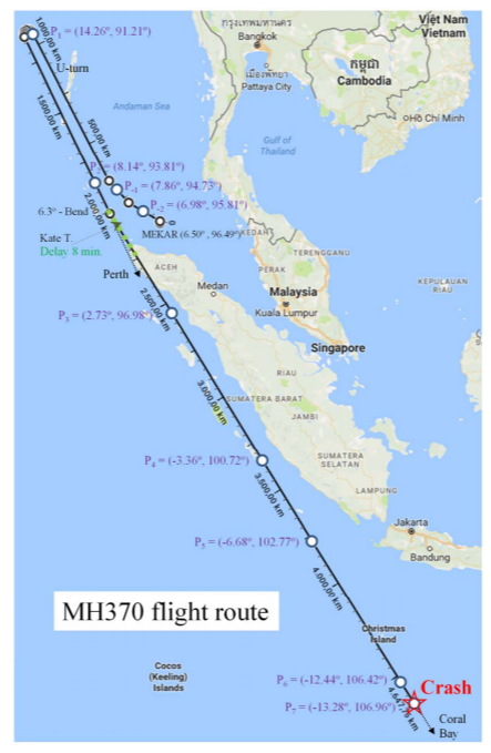
The broad details of the disappearance are well known. The journey began normally, with the plane following its planned route northwest toward Vietnam. But after the final voice communication with ground control, the plane deviated from this route, turned to the east, and flew back across Malaysia and out over the Andaman Sea. During this time it was tracked by Malaysian military radar but eventually flew beyond range.
After this, the only data from the aircraft comes from an onboard device known as a satellite data unit. This sent a “log on” request, presumably after rebooting for some reason. The device then responded with digital handshakes to hourly status requests from the ground that went unanswered by the cockpit.
These digital handshakes have been hugely important in working out where the aircraft flew next. The signals were relayed to the ground via a communications satellite called Inmarsat 3F1 that was geostationary over the Indian Ocean.
The difference between the time the signal was sent from the plane and the time it was received by the satellite has been a crucial clue for investigators. That’s because it determines the distance between the plane and the satellite. It defines a circle on the surface of Earth with the satellite at its center; at this time, the aircraft must have sat somewhere exactly on this circle.
The aircraft sent seven of these digital handshakes. So the distance derived from these signals allows investigators to draw seven concentric circles that the aircraft must have crossed as it flew.
But exactly where the plane crossed each circle is unknown, and its trajectory cannot be determined from this information alone.
However, there is another clue buried in these digital handshakes. The aircraft’s movement relative to the satellite creates a Doppler shift in the frequency of the radio signals. And since Inmarsat recorded the precise frequency of the signals, engineers can work out the relative velocity of the satellite and the aircraft.
This provides more information about the aircraft’s motion but does not give a unique solution. That’s because the Doppler shift records only the relative motion of the plane and satellite toward or away from each other. The satellite’s motion is known, but the plane’s motion might have other perpendicular components: lots of different trajectories can all produce the same Doppler shift.
Kristensen’s analysis creates a mathematical model of all these factors, which produces four solutions. Each solution is a potential location for the aircraft that is consistent with all the data.
Two of these locations are to the north and over land. Kristensen dismisses them quickly. He says an aircraft in this region would have been picked up by Chinese or Indian military radar. Any mobile phones left on by passengers would have attempted handshakes with networks on the ground, but there is no evidence of this. Neither is there any debris from a crash in these areas.
By contrast, the only debris recovered so far is from the ocean, clearly suggesting that the aircraft came down over water.
The third solution from Kristensen’s analysis is the location that has already been searched extensively. There is no sign of the aircraft here.
But the final solution is in a new location that search teams have not considered in detail. It lies close to Christmas Island in the Indian Ocean and is a much smaller area than that searched already.
For the aircraft to have crashed here, it must have executed a U-turn somewhere to the north of Indonesia and then flown southwest over the Indian Ocean, roughly parallel with the Indonesian coast. Indeed, there is an eyewitness statement from a fishing boat in this region that claims to have seen the aircraft that night, flying relatively low in this area.
Kristensen’s analysis suggests the plane must now lie in an elliptical region of ocean, some 140 kilometers (87 miles) long and 30 kilometers wide. “The probability of finding the plane there is above 90%,” he says.
That’s interesting work that could provide the additional data needed to restart the search. Kristensen says this location is also consistent with other data, such as the study of barnacles on the washed-up aircraft debris. He says this suggests the aircraft must have crashed in a more northerly location than was originally searched.
Kristensen also offers some grist for the conspiracy theorists’ mill. The data analysis cannot tell how high the plane was flying during its last hours. So the eyewitness statement that it was flying relatively low is something of a mystery.
But Kristensen has a theory about the pilots. “The only plausible explanations are that they wanted to land in Banda Aceh or abort the flight by parachute,” he says. “Since the airplane did not land, the only option is parachuting.” This would have required the plane to fly low and relatively slowly, just as was observed. The pilots must then have programmed the plane to return to normal flying height after they had bailed out.
Of course, extraordinary claims require extraordinary evidence, and of that there is precious little right now. But if Kristensen’s conclusion helps find the plane, then he will have helped to have settled one of the greatest aircraft mysteries of all time.
Ref: arxiv.org/abs/1811.09315 : How To Find MH370?
Deep Dive
Climate change and energy
The problem with plug-in hybrids? Their drivers.
Plug-in hybrids are often sold as a transition to EVs, but new data from Europe shows we’re still underestimating the emissions they produce.
Harvard has halted its long-planned atmospheric geoengineering experiment
The decision follows years of controversy and the departure of one of the program’s key researchers.
Why hydrogen is losing the race to power cleaner cars
Batteries are dominating zero-emissions vehicles, and the fuel has better uses elsewhere.
Decarbonizing production of energy is a quick win
Clean technologies, including carbon management platforms, enable the global energy industry to play a crucial role in the transition to net zero.
Stay connected
Get the latest updates from
MIT Technology Review
Discover special offers, top stories, upcoming events, and more.